Water
Level
Lake
Level & Precipitation Summary by the Devils Lake Water Improvement
District (DLWID)
The Devils Lake Water Improvement District has a permit to impound water on
Devils Lake to maintain a level of water suitable for recreation during the
summer months. Boards are placed in a dam-like structure at the D River to
control the lake level.
The lake
level can also be influenced by sand blocking the D River. NOAA Fisheries
and the Army
Corps of Engineers have put special conditions on clearing the D River
Channel. They want to limit that activity from December 1 to February 15 due
to concerns
over coho fisheries. It is interesting because the peak of that coho
run is between December and January. The city files conditions of that permit
and sends it to Nebraska.
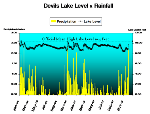
The Lake Level and Rainfall Summary is courtesy of the Devils Lake Water Improvement District
_______________________________________________________________________________________
Water
Year
The water year begins in October. Year to date rainfall measurements begin in
October.
_______________________________________________________________________________________
4/16/07
Dear PADL,
The dam at the D River is in, and will remain in barring any unforeseen
requirements until October. We will be opening up part of the dam (1 section)
every other night in May for the facilitation of Coho smolts’ passage to
sea. This will result in some fluctuation diurnally during that period,
but for the most part the lake level should vary only slightly dependent of course
on the precipitation through the summer, or lack there of. As to
the lake level in August, 10.4 is normal high water mark for Devils Lake, and
thus 12’ is 1.6 feet above flood stage. Last year, the lake dropped
only once below 9.00 feet and then only to 8.99’. This was widely
regarded as the highest it had been maintained through the summer in years, thanks
to repairs done on the dam, and the diligence of Steve Hoover our Lake Contractor. We
at the District will again strive to maintain a high enough lake level
for recreational use in balance with the needs of Fish and Wildlife, and
at odds with Mother Nature.
We will be posting the lake level on the web at http://www.DLWID.org each
week under the Water Quality Page, so you can find that information readily. Should
you have any further questions as to lake level management or any other topic,
please feel free to contact the District. Thank you for your ongoing
interest and support of Devils Lake.
Sincerely,
Paul Robertson, Lake Manager
Devils Lake Water Improvement District
_______________________________________________________________________________________
4/2/09
- Lake Level: DLWID board voted for a lake level at 9.6 to
comply with the water resources compound water permit (Beamer out of Tillamook).
Since the remodel of the D River dam more water was compounded than allowed by
the
water permit.
Approx.
50
people
attended
the
DLWID meeting with several testifying. Kerry Richards from Salem distributed
flyers.
Jonathan
Moll,
West
Devils Lake
State
Park manager,
spoke about park flooding and the sewer pump station and manhole. Water skier
Randy Weldon circulated a petition to lower the lake level closer to historical
levels before the dam was remodeled three years ago.
Kayakers
testified.
One was concerned about his beach in front of his property. DLWID manager Paul
Robertson
gave
an
educational
presentation.
_______________________________________________________________________________________
Devils Lake Water Improvement District manager Paul Robertson sent the following concerning an April 2, 2009 decision the DLWID board is considering about the lake water level.
Background: Many
reports have been given regarding the dam, including this one in October
2008:
Lake Level Update: Lake has varied only a few inches over the last month. Currently
the lake level is 9.6’ and with the rains we had it did increase slightly
but then returned to below the height of the lowest boards, and is now only
flowing out of the fish notch. With this reduced flow, we have again identified
a water quality problem associated with the dam. When the water stops
flowing over the dam, and is only flowing through the fish notch, there is
point where the water doesn’t draft off the top as there is a top bar
in the fish notch to provide strength. This backs up the water and floating
debris. What we have found in the past and again this week is that this
backed up surface water creates water quality degradation. The bar effectively
blocks the likes of surface scum including cyanobacteria up behind the dam. Toxic
levels of microcystin were documented in the scum that would have otherwise
flushed out to sea. Water quality is also reduced as we find higher E
coli readings when the water is not drafting off the top and pulling floating
material out to sea. We often find feathers which are associated with
sea gulls backed up behind the dam. I have been working with Steve to
redesign the outfall to always pull water off the top of the lake which should
help alleviate the problem. It is however a concern and would remain a concern
even if modifications were made as we are artificially slowing the water. The
dam causes stagnation, and stagnant water is not healthy regardless if the
top layer is being slightly drafted or not. Other issues with the dam: Installation,
maintenance and removal: This is an ongoing cost to the operation of the dam.
We pay Schooner Creek Construction $525 a month. It might be estimated
that 20% of the job description relates to the dam itself. Insurance: We
insure the dam for damage and is part of the $275 annual rate we pay for all
property owned by the District. Flooding: We have heard examples
of this particularly this year. Complaints about campsites being flooded,
shorelines being saturated have been documented. Recreation: We
have heard two sides to the recreation argument. One is boat access;
the other is choppy water, loss of beaches, soggy uplands and reduced use periods
of the lake and the shoreline as a result. The increased choppiness of
the water has been attributed to the lack of beaches to absorb wave energy. Rocked
and armored walls contribute to the choppiness as well. Erosion: we
have also heard of complaints of additional erosion from the heightened lake
level. Factors that would back up such claims are if shoreline plants
that are only adapted to partial (not year-round) inundation, may die and lead
to shoreline loss. A shoreline that has a water regime that fluctuates
more widely may have a series of plants with varying degree of water tolerance. This
natural transition is more capable of holding shorelines together, as upland
plants’ roots tie in with the facultative wetland plants (those that
can stand some water), and the facultative wetland plants roots tie into the
roots of obligate wetland plants (those plants that require water saturation),
which mesh with submerged aquatic plants. Artificial height control may
limit this transitional plant ecology as it may favor aquatic plants over facultative
wetland plants and more upland species which have stronger root systems. Wetlands: It
is difficult to gauge the net loss or gain of artificially raising the lake. Wetlands
are lost in one area as they become aquatic systems and may be gained in other
areas as uplands get inundated. In lake basins with steep side walls,
like a bathtub, wetlands would like be less affected by artificially raising
the lake level. The wetted areas would be just up higher. In more
complex basins like Devils Lake wetland gain and loss is much more difficult
to determine. Naturally wetlands grow and shrink year to year. Wetlands
are dynamic systems which are adapted to routine inundation and dry periods.
Water fluctuation is a natural part of the system. In shallow lake beds,
wetlands may spread out towards the lake quickly as the lake bed gets shallower
over geologic time. This wetland growth is tempered by large climatic
events and annual weather patterns that potentially decrease wetland expansion
with high water flows which cause erosion. Wetlands rely on the alternating
cycle of dry and wet weather. Nutrients are brought into the wetland
during flooding and high water. During dryer, sunnier times wetlands
take advantage of the nutrients to photosynthesis and increase root mass. This
is the natural boom and bust of wetland cycles. Artificial control over
water height generally limits then where wetlands can grow and thus may generally
have a negative effect on their viability. Wetlands provide immeasurable value
to lakes and wildlife, but certainly increase water quality by using nutrients
and blocking sediment. When wetlands die back, they decompose and provide
chemical decomposition products (hydrogen peroxide) that inhibit cyanobacteria. As
much of Devils Lake is developed, the best spot for increasing wetlands maybe
towards the lake center verses towards uplands where development has decrease
the biodiversity. Therefore wetlands are likely more favored without
artificial augmentation which allows vegetation to grow lake ward and expand
the riparian wetland buffer. Wildlife barrier: the
dam in the summer is a barrier to young flightless birds. The slope of
the land on either side does not lend it self to being traversed and routinely
young birds are trapped below the dam for often hours at a time. They
risk injury as they try to get over and around the dam. Fish: The
dam is built with only the most minimal fish passage requirements. This
is a notch in the dam 6” wide. This is not a problem in the
winter as the dam is taken out in October, but in the spring fish are migrating
to sea. Smolts use flow as a cue to find the ocean, and thus putting
a dam in when the fish are looking for the cue to find the ocean is counter
to their survivability. We have attempted to pulse the dam during the
night when their outward migration is the highest (May). Other fish issues
include when a fish gets accidentally flushed out to the D River. Only
the really strong swimmers have much hope of swimming through the forceful
water that flows out the fish notch. The notch is really only meant for
downstream passage for outward migrating smolts. I have seen a few carp
get flushed out the dam, one at least was able to get back through the velocity
barrier that the rushing water through the fish notch is. Pacific Lamprey: Native
lamprey migrate in and out of coastal systems. They like salmon are born
in freshwater systems and head to sea, only to return to freshwater to spawn. The
Siletz Tribe is building the knowledge base around these anadromous organisms
in our area which have bee greatly impacted by development. It is known
that the Pacific Lamprey migrate back to freshwater in the spring time and
have only limited food reserves for this migration. Dams are obstacles
to their migration and are known to reduce the viability of these native animals. As
Devils Lake has native spawning ground for Coho, it is expected that Pacific
Lamprey may have inhabited our area as well, and may in fact be present at
some low level.
More Background and a summary of input: 2009-03-27 Devils Lake was been
artificially raised in the summer since about 1996. This has kept the
lake higher by approximately 1-2 feet depending on how well the dam was maintained
and from where the mean low level might have been. Little is documented
about the actual normal low level that occurred before the dam and before the
grass carp. While the mean high level has been known to be 10.4’,
no datum exists to my knowledge of a mean low, but 8.3 seems to be about the
lowest the lake has gotten since consistent records were kept in 1997. These
lows occurred after presumable the dam might have been removed in October.
The other records we have I presented last month and are summarized again
in this graph. As the data represents a time before the lake was artificially
augmented, the lowest values occurred predictably in summer. From these
data it would seem that the lake varied no more than some 18” year to
year in the mid-1980s to early 1990’s.
The normal operation of the dam has been to put the dam in on or near April
15th, using 3 stacked 4”x8” boards laid lengthwise across the cement
base. The boards are held in place by the metal I beam super structure
bolted to the cement. A fish passage notch 6” wide and as
deep as the height of the boards is left open throughout. In mid
May the dam is opened up in one 8 foot section all the way to the base of the
concrete to facilitate the outward migration of threatened Coho salmon. This
usually is done every other night for the course of the night between May 15th
and May 31st. After May the dam is left in place until Oct 15th or so
when the entire structure is removed. This is done to prevent damage
from winter storm surges up the D River. In accordance with the water use permit,
after July 1st in the year no additional water may be backed up, thus the output
through the D River must equal the influx through streams.
In March of 2006 the dam was repaired and the water was maintained at from
10.0’ to a low of 8.95 at the end of the summer. The year before,
the lake was maybe 8.9’ by August. Many lakefront owners
applauded this repair, noting better boating access in the summer of 2006. One
or two dissents were also received. In 2007 the lake varied between 10.0 to
9.12’. The State Park complained in early spring about flooding,
but by opening and then fully shutting the dam the problem was alleviated and
did not return during that year. A contractor on the lake came before
the board requesting the lake be kept at 10.0’.
Last summer (2008) complaints were received from the State Parks about flooding. The
District responded to these complaints by releasing water through May 31, 2008. After
we reinstalled the dam, the complaints returned. This was different from
the year before when we released water at their request, and then the park
remained dry for the summer of 2007. Aggravating circumstance revealed
indicated that the State Parks had dredged the canals that lead to the lake
from their property. This allows water a direct path into and out of
the park. This alone might not account for flooding though as some level
of connectivity would exist through the ground water irrespective of the canals. Creating
these canals though is likely to have caused subsidence of their property. Opening
up wetlands to oxygen creates an oxidizing environment, which tends to more
rapidly decay the peaty bog material which forms much of the property. In
this oxidizing environment plant material that otherwise would be accumulating,
degrades though microbial decomposition. This can lead to subsidence
of the entire wetland which may explain for the near year-round inundation
of certain campsites.
At the request of the State Park, Oregon Water Resources Department conducted
a review of the permit. Their findings reported just last meeting indicated
that some error was made in calculating the board space that would impound
the amount of water legally described in the water storage permit. The
permit clearly stated that the District could use up to 3 stacked 8” tall
boards. This qualified for approximately 24” of impoundment above
the cement structure. Using nominal sized 4”x8” boards (which are
3 1⁄2” x 7 1⁄2“), the effective impound was 221⁄2 “. The
cement base was also clarified to be at 8.03 above mean sea level during this
permit evaluation as had been the case since 1992 when it was rebuilt. Upon
Water Master Greg Beaman’s review, the correct height of stacked boards
should have only been 18”. This would place the maximum height
at 9.53’ above sea level.
During the course of last summer other concerned property owners also voiced
opposition to the height of the dam. A petition received by the District
and signed by 21 property owners sought a lowering of the dam to 9.0’ during
the summer. Reasons for the reduction were centered around the claim
of severe erosion, loss of beaches that would otherwise dissipate wakes, and
loss of recreational use due to choppy water from the bathtub effect of reverberating
wave energy against hardened surfaces such as rock retaining walls and rip
rap. The board was later provided with photographs of properties claiming
erosion. Several (5-7) individuals came to the board meetings in support
of this petition over the course of the last 12 months.
Opposition to this proposal has also been voiced. Approximately 5-7 individuals
have come before the board or provided email or blog comments to voice their
opinions on the lake level. Arguments for keeping the lake level at
its maximum included the loss of boat access, that the lake is artificially
controlled
in the winter for emergency dredging, lowering the available pool of water
in the summer, the erosion effects of waves in shallow water, and loss of
property value.
A third set of voices pressing for the removal of the dam was also heard. Individuals
reporting in person and through email prompted for the allowance of natural
water fluctuation to facilitate wetland functions, fish & wildlife migration,
and to reduce erosion. The reservoir like management of a lake decreases
vegetative shoreline productivity, leaving a ring around the lake void of vegetation
which would have grown during the summer but was inundated with the recreational
water impoundment.
Sincerely,
Paul Robertson, Lake Manager
Devils Lake Water Improvement District
www.DLWID.org
• P: (541) 994-5330
• F: (541) 994-6040
• E: paul@DLWID.org
site map
home
Copyright © 2003-2011 Preservation Association of Devils Lake (PADL).
All rights
reserved.
P.O. Box 36
Lincoln City, OR 97367
PADLsteward@wcn.net