 About:
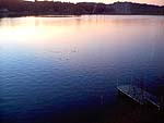
Devils Lake
About:
Devils Lake
Devils Lake Watershed
D River
Devils Lake is located on the central Oregon Coast, bordered by Lincoln City
and Lincoln County land. About half of the lake is outside the city, but within
the
Urban Growth Boundary (UGB). The lake connects to the Pacific Ocean by the D
River, once considered the shortest in the world. (Roe River in Montana also
claims to be the
shortest river in the world. The 2006 Guinness Book of World Records does
not recognize the shortest river.)
To
the
east
of
the
lake
is
the
Siuslaw
National
Forest.
Devils
Lake
Length: Approximately
3 miles long
Width: Averages about 0.4 miles in width
Depth: Shallow, maximum depth of 22 feet (6.7 m), average 10 feet (3
m)
Drainage Basin: D River (Pacific Slope drainage)
Drainage Area: 12.8 sq. mi.
Surface Area: 680 acres (Information furnished by the Oregon State Wildlife
Commission.)
Surface Elevation: 20 ft. (6.1 meters) above mean sea level, from topographic
map.
Volume: 6,800 acre-ft. (Information furnished by the Oregon State Wildlife
Commission.)
Inflow: Largely from Rock Creek on south end of the lake, and from Thompson
Creek, on northeast end, and several unnamed streams contribute some inflow.
Outflow: Flow through D River on southwest end of lake estimated to be
nearly equal to the total inflow.
(Information courtesy of the U.S. Department of the Interior.)
Length of Shoreline: 10.7 mi. (17.2 km)
Retention Time: 2 mo
Location Coordinates: 44 deg, 58 min, 02 sec N;
124 deg, 00 min., 51 sec W
Mid Coast Basin
Information from the Atlas of Oregon Lakes
The Department of Environmental Quality (DEQ) is responsible to protect the
water quality in Oregon under the Federal Clean Water Act.
| Area |
684 acres |
270.7 ha |
| Depth |
21.1 ft |
6.4 m |
| Average Depth |
8.4 ft |
2.56 m |
| Volume |
5745 ac. ft. |
7.092 m3 E6 |
Data from
Joe Eilers, MaxDepth Aquatics, Inc. 2004
Definitions:
Lake: A body of water of considerable size, surrounded by land, and too
deep for plants to grow except around the shore.
Limnology: is the scientific study of bodies of fresh water with reference
to their physical, geographical, and other features.
Paleo-limnology: is the scientific study of sedimentation of the lake
bottom.
Riparian areas: are defined as of, or pertaining to, or situated or dwelling
on the bank of a river, stream or other body of water. Riparian areas support
more species than any other habitat type in Oregon, including fish, plus 44%
of all other animals, including bats and 56% of all neotropical migratory birds.
Stewardship: is defined as individual or collective practices that demonstrate
a long-term commitment and a sense of personal responsibility for a particular
resource.
Urban Growth Boundary: an area designated for potential growth of the city.
Watershed: is the area to which all water, sediments and absorbed materials
flow or drain from land into a common body of water such as a river or lake.
Wetlands: are defined as lands transitional between terrestrial and aquatic
systems where the water table is usually at or near the surface or the land
is covered by shallow water. Wetlands usually have three components: 1) surface
water or water in the root zone, 2) hydric soils or undrained soils, 3) vegetation
adapted to thrive in wet conditions (hydrophytes).
Oregon's wetlands provide a multitude of benefits for humans
and the ecosystems in which we live, including:
• Habitat for a major portion of the state's fish and wildlife, including
waterfowl and other migratory birds of the Pacific Flyway; salmon; and dozens
of threatened and endangered species.
• Flood control and protection against storm damage.
• Water quality improvements through absorption and filtration of sediments,
nutrients, metals and toxic materials.
• Opportunities for public recreation, education and research.
• Open space and scenic values.
For more information about wetlands visit the Oregon Habitat
Joint Venture at www.ohjv.org/oregons_wetlands.html.
Another website is the Department of State Lands Wetlands Program at statelands.dsl.state.or.us/wetlandsintro.htm.
Devils Lake Watershed
Drainage Basin: D River (Pacific Slope drainage), 24 sq. mi. (60
sq km)
Precipitation: 90-112 in.
Relief: Moderate
The Devils Lake watershed covers a large portion of Lincoln City - from the
north end of Lincoln City to Taft High School in the south. To the east of
Devils
Lake is the Siuslaw National Forest. The forest is home to the marbled murrelet,
an endangered species of bird.
The two largest inflows are two streams, Rock Creek and Thompson Creek. Rock
Creek, the principal source of inflow surface, drains about 60 percent of
the
basin. It drains an area of predominately undeveloped, forested, steep sloped,
mountainous terrain. The upper area is managed for timber. Thompson Creek
drains
the moderately sloped northern portion of the drainage basin, and is an area
which is principally developed residential.
(Atlas of Oregon Lakes)
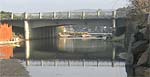 D
River
D
River
Length:
120 feet (37 meters)
Oregon Coast Today article: www.oregoncoasttoday.com
Boards: Boards have been placed at the D River to control the water level
of the lake. Under the lake impounding permit, DLWID must remove the boards in
the fall every year. The boards are 6 inches deep, and are stacked several on
top of each other.
Dredging: Periodically beach sand, deposited from wave action and winter
storms, blocks the D River channel. A dredger is brought in to clear the channel
of sand and logs brought in by winter storms. The sand must be dumped back
on the beach. NOAA Fisheries and the Army Corps of Engineers
have put special conditions on clearing the D River Channel. They want to limit
that
activity from December 1 to February 15 due to concerns over coho fisheries.
It is interesting because the peak of that coho run is between December and January.
The city files conditions of that permit
and sends it to Nebraska.
Salmon Smolt Trap: The Oregon Department of Fish and Wildlife, at certain
times of the year, places a smolt trap (a rectangular, green box) at the D River
to monitor coho salmon migrating out to the ocean.
D River State Recreation Site: For information and a panoramic
view
of
the
site
visit www.oregonstateparks.org/park_214.php.
In
the State Parks website click
on "See more photos" to view the panorama. The panorama takes time
to load
but is worth the wait.
Photos: Devils Lake (Susie Fischer), D River (R. Erickson)
site map
home
Copyright ©
2003-2011 Preservation Association of Devils Lake (PADL).
All rights
reserved.

P.O. Box 36
Lincoln City, OR 97367
PADLsteward@wcn.net